|
B.C.
Provincial Parks of Peace River & Alaska Hwy Region
Andy
Bailey Recreation Area | Beatton
| Buckinghorse River | Carp Lake
Charlie Lake | Crooked River
| Gwillim Lake | Kiskatinaw
Liard River | Moberley Lake
| Monkman | Muncho Lake
One Fifteen Creek | One Island
Lake | Prophet River | Stone
Mountain
Swan Lake | Tetsa River | Tudyah
Lake | Whiskers Point
ANDY BAILEY RECREATION AREA
A popular lakeside destination southwest of Fort Nelson, 12 km (7 mi)
off the Alaska Highway 97. Encompassing 174 ha (430 ac), the recreation
area offers 19 campsites situated in a spruce forest. A boat launch is
provided to make your fishing more enjoyable.
BEATTON PROVINCIAL PARK
This park contains 312 ha (770 ac) on the east side of Charlie
Lake, just 13 km (8 mi) north of Hwy 97 at Fort St. John. Featuring
37 lakeside campsites, a playround, picnic area, boat launch and
sandy beach, Beatton Provincial Park is a great place to spend some
time and fish for walleye and northern pike. Reservations are accepted.
BUCKINGHORSE RIVER PROVINCIAL PARK
Located at Mile 173 (278 km) of the Alaska Highway, this 33
site provincial campground and park lies on 55 hectares (136 acres)
along the Buckinghorse River. When stopping for the night, take
some time to try your hand at fishing.
CARP LAKE PROVINCIAL PARK
The park area covers more than 19,000 hectares including Carp
Lake, War Lake and numerous other lakes and streams making water
activities the most popular pastime within the park. At McLeod Lake,
141 km (88mi) north of Prince George, turn off the John Hart Highway
#97. It is 32 km (20 mi) to the Carp Lake Campground. Two campgrounds
offer a total of 102 sites, as well as wilderness camping. Trails
connect with Rainbow Lake, McLeod River and two of Carp Lakes beautiful
sandy beaches.
CHARLIE LAKE PROVINCIAL LAKE
Nestled in the aspens on the southwest shore of Charlie Lake,
the 92 ha (227 ac) park offers 58 campsites, picnic area, playground,
sani-station, and boat launch. Walking and hiking trails lead through
the forest. Fishing for walleye and northern pike is popular. The
park is located near the junction of Hwy 29 and Hwy 97 about 20
km (12 mi) north of Fort. St. John.
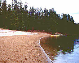
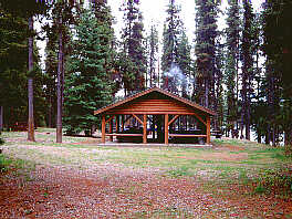
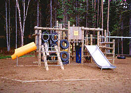
CROOKED RIVER PROVINCIAL PARK
The beautiful Crooked River Provincial Park is located on the
Hart Highway #97, 70 km (44mi) north of Prince George and offers
many popular sandy beaches. Crooked River, Squaw Lake and Hart Lake
are popular with both canoeists and anglers. There is a 90 unit
campground within the park and nine kilometres of trails where outdoor
enthusiasts can discover the beautiful area and its abundant wildlife.
Reservations are accepted. Photo
1 | Photo 2 | Photo
3
GWILLIM LAKE PROVINCIAL PARK
Located almost half way between Tumbler Ridge and Chetwynd,
Gwillim Lake Provincial Park is 9,199 ha (2,272) set in the foothills
of the Rocky Mountains on Highway 29 South. Campers will enjoy the
49 forested sites overlooking the lake. Park facilities include
a boat launch, 32 day use picnic sites and dry toilets. Be sure
to take your camera and binoculars and visit the viewpoint.
KISKATINAW PROVINCIAL PARK
Located just 5 km (3 mi) east off Hwy 97, 34 km (21 mi) north
of Dawson Creek, the park offers 28 campsites on the south bank
of the Kiskatinaw River. Stroll along the river and see the historic
curved wooden trestle bridge built in 1942.
LIARD RIVER HOTSPRINGS
The bubbling waters of Liard River Hotsprings are a tempting
invitation for travellers to stop and relax at Mile 496 (798 km)
of the Alaska Highway, 317 km (197 mi) northwest of Fort Nelson.
The natural hot springs result in a unique environment for outdoor
enthusiasts. The 668 ha (1650 ac) park offers 53 campsites, a picnic
area, playground, and short hiking trail. Reservations are accepted.
MOBERLEY LAKE PROVINCIAL PARK
Located 26 km (16mi) northwest of Chetwynd 3km (2mi) off Highway
29, Moberley Lake Provincial Park is a popular spot for swimming,
boating and picnicing. Visitors will enjoy the interpretive nature
trail. A playground is provided for youngsters. Set in a spruce
forest, the 97 ha (240 acre) park offers 109 campsites and picnic
sites. Reservations are accepted.
MONKMAN PROVINCIAL PARK
This 32,000 ha (79,040 acre) wilderness park is located about
45 km (28 mi) south of Tumbler Ridge off Highway 29. Facilities
include 42 forested campsites, picnic sites, and 22 km (14mi) of
hiking trails. Monkman Provincial park is famous for Kinuseo Falls,
a breathtaking stretch of the Murray River.
MUNCHO LAKE PROVINCIAL PARK
Situated on the east side of Muncho Lake on the Alaska Highway,
245 km (152 mi) west of Fort Nelson this 88,416 ha (218,387 ac)
park offers two provincial campgrounds with a total of 30 sites
on Muncho Lake. Dry toilets. Boat launch & fishing. Reservations
are accepted.
ONE FIFTEEN CREEK PROVINCIAL PARK
At Mile 385 (620 km) of the Alaska Highway, where One Fifteen
and McDonald Creeks meet, is this handy campground and roadside
rest area. The 51 ha (126 ac) park has camping sites for 8 units.
ONE ISLAND LAKE PROVINCIAL PARK
A 61ha (151 ac) campground and park located on the southeast
shore of One Island Lake 24 km (15 mi) off Highway 2 at Tupper,
southeast of Dawson Creek. This crystal clear lake is noted for
it's fishing, and a boat launch is provided. Swimming and watersports
are also popular. The facilities include 30 campsites and a picnic
area.
PROPHET RIVER PROVINCIAL RECREATION AREA
The Prophet River Recreation Area encompasses 115 ha (284 ac)
overlooking the river at Mile 217 (350 km) of the Alaska Highway.
Facilities include 45 forested sites. Hike to the river below and
try your hand at fishing.
STONE MOUNTAIN PROVINCIAL PARK
Located at Mile 373 (600 km) at the highest point on the Alaska
Highway, 139 km (86 mi) west of Fort Nelson, this 25,691 ha (63,457
ac) park offers visitors a chance for an adventure in the Rocky
Mountains. Camp at Summit Lake, elevation 1267 metres (4156 ft)
and then hike into nearby sub alpine lakes. Take the camera along,
you'll see some breathtaking vistas and wildlife. Be sure to cast
a fishing line into Summit Lake. The campground offers 28 sites.
SWAN LAKE PROVINCIAL PARK
One of the first provincial parks to be established in B.C.,
Swan Lake Provincial park is located near Tupper, southeast of Dawson
Creek. The 67 ha (165 ac) park offers 42 campsites located on the
lakefront. The kids will enjoy the playground and water sports.
A boat launch is provided and fishing is popular.
TETSA RIVER PROVINCIAL PARK
77 km (48 mi) west of Fort Nelson, at the confluence of Tetsa
River and Mill Creek, is the 115 ha (284 ac) Tetsa River Park. The
park offers 25 campsites and a chance to fish the river and creek.
TUDYAH LAKE PROVINCIAL PARK
Just north of the community of McLeod Lake, near the junction
of Highways 97 and 39, is Tudyah Lake Provincial Park. This 56 ha
(138 acre) park includes 36 campsites and picnic sites set on the
south end of the lake. Swimming and fishing are popular activities,
and a boat launch area is provided.
WHISKERS POINT PROVINCIAL PARK
The park is found on a secluded peninsula reaching into historic
McLeod Lake. This area was once admired by explorer Simon Fraser
who established Fort McLeod in 1805. The park is the perfect base
from which to explore the area. It is located 130 kilometres north
of Prince George on the Hart Highway #97. The campground is located
on the sandy point of the peninsula and features 69 private sites.
A nature trail loops through the woods to the campground.
|
