This region
of Northern British Columbia
borders Alberta to the east and both the Yukon and Northwest Territories
to the north. Much of it lies on the east side of the Rocky Mountains.
Rolling plains, mountains high, rushing rivers and streams and miles of
forests make up the Peace River/Alaska
Highway, where wilderness areas are the norm not the exception. Once
upon a time, dinosaurs roamed this region and the aboriginals date back
some ten thousand years. Summer days are long and warm, winter days are
short and cold, the land of the midnight sun is closer in the Peace Country.
The main
industries are farming, logging, as well as gas and oil. People of the
Peace are still pioneers and travellers quickly notice the laid back attitude
and friendliness of the residence in this region. Starting from Dawson
Creek, the Alaska
Highway cuts through this northern region of BC as it makes its way
to the Yukon and Alaska. Nature has not been tampered with and the adventures
never stop, they include mountain
climbing, whitewater rafting,
canoeing and kayaking, horse
back riding, gold panning, hunting, fishing
and ample hiking trails. When exploring the roadsides, they can quickly
turn to wilderness and terrain can be rough and you could find yourself
venturing into the unknown. Always be prepared!
Monkman
Provincial Park: Monkman
Provincial Park, south from Tumbler
Ridge, rewards you with the Kinuseo Falls. Your adventure starts from
the campground, that's 45 km (28 mi.) from Tumbler Ridge. A short walk
from the Kinuseo Falls Campgrounds will take you to a viewing platform.
Both the sound and spray of the falls needs to be experienced to be appreciated.
A hiking trail from the campground will take you into the middle of the
park and the Murray River Crossing. The south end of Monkman Lake is a
24 km (15 mi.) hike. There are primitive camp sites in this region which
is bear country. Keep food away from your
sleeping area, keep the area clean and watch for these four legged creatures
that call this home.
Monkman Provincial
Park is located in the Hart Ranges of the Central Rocky Mountains and
foothills. This provincial park offers a diverse and inspiring landscape
of jagged peaks, forested valleys, unique geological formations, pristine
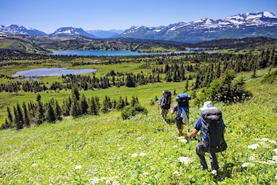
lakes and alpine meadows. Opportunities to explore encompass the gamut
from easy two-hour trails, to challenging multi-day adventures with many
possible side trips available for seasoned and adventurous hikers that
can make for an expedition of seven to ten days.
Special features
of Monkman Provincial Park include:
Kinuseo
Falls which plunges 197 feet (60 metres) into the canyon below
a series
of ten waterfalls named the Cascades
Stone
Corral Trail, one of Monkman Provincial Park's most notable hikes, which
leads visitors to small caves with stalactites, moonsmilk and other
limestone formations.
The tarns
region, Fontoniko valley, and numerous historic markings along trails.
The Monkman
Pass Memorial Trail Hiking Route, in Monkman Provincial Park, goes through
four different eco-regions … boreal, subalpine, alpine, and Columbian
forest. The region traversed by the trail is remote rugged wilderness
and the trail is classified as "difficult". The park offers
a diverse and inspiring landscape of jagged peaks, forested valleys, unique
geological formations, pristine lakes and alpine meadows.
Northern
British Columbia's "Monkman Pass Memorial Trail Hiking Route"
is an unforgettable hiking route that includes major waterfalls and rivers,
lakes, temperate boreal forest, as well as alpine meadows and alpine summits.
This is an average six day journey on a wilderness trail that leads through
magnificent, remote, untouched mountain terrain, filled with an with inspiring
and tangible history, and sightings of Grizzly and Black Bears are numerous.
This hiking
trail, a true wilderness experience, follows the route that Alex Monkman
and pioneer residents created in the 1930s. Monkman Pass was surveyed
as an alternative route through the Rockies, but the highway was never
built. The majority of this spectacular, but little-known trail is in
Monkman Provincial Park. The trail leads from one of its most famous features
the Kinuseo Falls, and over the Rocky Mountains to Hobi's Cabin on the
Herrick River.
Information & Services
If you would like to have your business listed, please Click Here.
680 km (421
mi.) beyond Dawson Creek on the Alaska Highway lies Muncho Lake and Muncho
Provincial Park. The drive through the park which is 90 km (55 mi.)
has a reputation of being the most scenic part of the Alaska Highway. After
setting up camp at Muncho, enjoy day hiking the surrounding terrain. In
the Toad River Valley, you will often see moose roaming and at the mineral
licks in the western region of the park, stone sheep and caribou are frequent
visitors.
Excellent back-country
hiking and the superb beauty are the drawing cards to Stone Mountain Provincial
Park and the Wokkpash Recreation Area, that lie west from Fort
Nelson. The highest point on the Alaska Highway, Summit Pass, is in
the park. Both Summit and Rocky Crest Lake are excellent places for bird
watching. Hike into see the hoodoos on the Erosion Pillars Trail, with access
from Rocky Crest picnic area. The five to seven day Wokkpash Trek is gaining
popularity and takes you into a lunar type landscape of marvellous hoodoos.
From these rock formation, the hiker is soon viewing Forlorn Gorge, a very
picturesque canyon that's 25 metres (80 feet) wide and 150 metres (490 feet)
deep. From here the trail loops north to MacDonald Creek and the Alaska
Highway. This is remote wilderness hiking so come equipped. Be safe, have
fun!
The Kwadacha
Wilderness Provincial Park is wilderness to the extreme and a place for
wildlife like wolves, elk, grizzly and black bears. There are no roads
into Kwadacha but you can use one of the two guide-outfitter routes that
lead into the park, or take the easier way and fly in. Trails within this
park are not maintained and your wilderness navigation skills will be
needed. This is rough country and only very experienced back country hikers
should venture here. Weather conditions can change suddenly, be ready
for rain and snow. Safety should be your first concern in this region.
Be safe, have fun.