The Chilkoot
Trail, was the most famous route taken by prospectors and would be miners
who made their way to the Klondike Gold Rush in the Yukon. It all started
when gold was discovered in the year 1896 on Bonanza Creek, a tributary
of the Klondike River, just 17.7 km ( 11 mi.) from Dawson City. In 1897
when the word got on, the Klondike Gold Rush was on. People from all walks
of life, stampeded to the gold fields. The most popular route to the gold
fields, was over the Chilkoot Pass from Alaska through British Columbia
and into the Yukon.
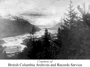
The Chilkoot
Pass, was an aboriginal trail that had been used for years by the First
Nations people who lived in this region. The complete journey meant, a
trip by ship from Seattle, Washington to the town of Skagway in Alaska.
From here it was overland by way of the Chilkoot Pass to the headwaters
of Yukon River at Lindeman Lake or onto Bennett Lake, both located in
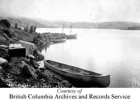
British Columbia. To continue the rest of the way to Dawson City, the
prospectors and miners built boats and rafts that were put into the water
at either Lindeman or Bennett and the trek was completed by water
Information & Services
If you would like to have your business listed, please Click Here.
The Original
Chilkoot Trail of 1897
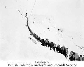
The topography
and the weather made this trip extremely harsh, and adding to the very
harsh conditions, was a law that stated all who entered Canada could only
do so, if they brought in their own food supplies that would last them
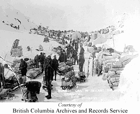
a year. To enforce this regulation, at the summit of the pass was a North
West Mounted Police Station. This regulation meant that every miner had
to haul almost 900 kg (a ton) of food over the border. This could take
a person close to three months to haul gear from cache to cache. After
they reached the summit and the B.C. border, they still had a long way
to go to reach Dawson City in the Yukon. Most made the rest of the trip
by either boat or rafts they built at either Lindeman or Bennett. The
trip up the Yukon was no picnic. It was a long, hard trek with many rapids
that had to be traversed.
Today the
trail from Dyea, Alaska to Bennett, British Columbia is the only part
of this historic trail that is maintained. It is approximately 53 km (33
mi.) in length and is jointly administered by the U.S. Park Service and
the Canadian Park Service.
The Chilkoot
Trail Mile 0 is at Dyea, Alaska, which is 13 km (8 mi.) from Skagway,
where you can get the latest information about the conditions of the trail,
directions and transportation to the trailhead. There are four public
shelters along the trail and campsites are well marked, but during the
busy months of June, July and August you are not allowed to use the shelters
for sleeping.
The summit
is 939 m (3246 ft.) high, but remember you start the hike at sea level
and have to make your way to the summit and down again. Along the way
you could encounter snow, ice, fog and winds. Your first shelter is near
a waterfall at Canyon City and at this point you have hiked 12.4 km (7.75
mi.). As you leave Canyon City, you start climbing to km 20.8 (mile 13)
where you reach Sheep Camp. From this point of the trail till km 26.4
(mile 16.5) when you reach the summit, is a rough and grueling climb.
After you leave the Sheep Camp, trees give away to granite rock, boulders
and snow patches. From a place called the Scales you start climbing a
30-degree incline that was known as the Golden Stairs. The Scales got
that name, because of the fact that the miners when they reached this
point, would re-weigh their loads before heading for the summit and the
police patrol station. The name, Golden Stairs, came from the steps that
were carved out in the ice and snow by the boots of hundreds and hundreds
of miners that made their way up this extremely steep and harsh section
of the pass.
The Summit
(the British Columbia Section)
You have
finally reached the summit and are now in British Columbia. Take time
out and rest, only do not get too relaxed, because your next campsite
is 6.4 km (4 mi.) away. The trail down the summit is a sharp decline that
crosses a constant snow field. Keep to your right at this point of the
trail, as it cuts its way around the sheer side of Crater Lake. At km
33 (mile 20.5) you reach Happy Camp. This is a rather large flat camping
site, or if you wish you can hike a few kilometres further to the next
campsite, which is at Deep Lake.
The Canadian
side of the trail, is not near as gloomy as the west side of the pass.
The trail now takes you through spruce, alder, small willows and heather.
The mountains are not as severe, not as high, or as steep as you make
your way to Lindeman Lake. The campsite here is staffed by Parks Canada,
where you will find a first rate exhibition of trail memorabilia, diaries
and photos.
In order
to reach the end of the trail, which is at Bennett in British Columbia
you will have to hike another 11.2 km (7 mi.) after you leave the Lindeman
Lake Campsite. This will take about four or five hours. From Bennett,
there are a couple of alternatives you can take to reach the Alaska Highway
or Whitehorse. You can canoe down Lake Bennett, and the Yukon River to
Whitehorse. Or you can take the passenger boat that will take you to Carcross,
where Alaskon Express (Gray Line) buses pick up hikers and continues onto
Whitehorse or Skagway. Another interesting trip is to take the Chilkoot
Hikers rail shuttle from Lake Bennett to Fraser, and onto Skagway via
the White Pass or you can hike out to the Alaska Highway.
Essential
Information
This hike
is long and strenuous. It will take anywhere from three to five days to
complete. Do not miscalculate the hardships you might encounter on the
trail or the stamina you will need to complete the hike. It's best to
hike from Dyea, Alaska to Bennett, British Columbia and have the wind
and weather at your back as it is easier to climb up the Golden Stairs,
than to climb down. This section from the Scales to the summit is steep
and even seasoned hikers can be intimidated.
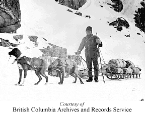
You should
go in self-sufficient and be prepared to backpack about 20 kg (45 lbs.)
of gear which should include waterproof and warm clothing and footwear,
as bad weather can hit anytime and hypothermia can happen. Included in
your camping gear should be a camp stove and fuel, as open fires are not
allowed on the trail. All along the trail you will find items that were
discarded by the prospectors as they made their way up and down the Chilkoot
Pass, do not touch or remove them. The law protects each and every piece
of gold rush artifacts that you might spot on your hike.
To provide
information and assistance to hikers and to also protect the historical
features and natural elements, there are park wardens and rangers at Skagway,
Dyea, Sheep Camp, Lindeman Camp and along the trail. This is not a wilderness
trail, and you will be sharing it with many other hikers, so wilderness
hiking courteous and common sense should be practiced at all times.
Hikers making
their way south to north, must pre-clear Canadian Customs. Report in person
or by phone to Canada Customs and Canada Immigration Centre at Fraser,
B.C. the phone number is (403) 821-4111 or call Whitehorse toll free at
1-800-665-8100. If hiking from north to south, you are required to report
to U.S. Customs at Skagway.
For more
information on the Chilkoot Trail contact
Parks
Canada
Yukon National Historic Site
Room 205 - 300 Main Street
Whitehorse, Yukon Y1A 2B5
Telephone (403) 667-3910
Fax: (403) 393-6701
or Klondike Gold Rush National Historic Park
Box 517
Skagway Alaska 99840
Telephone: (907) 983-2921