One
of the few remaining Cariboo Gold Rush settlements, Likely,
British Columbia, is a small community situated where the
west arm of Quesnel Lake
empties into the Quesnel River, near the southern end of
the Matthew River Road leading to Barkerville.
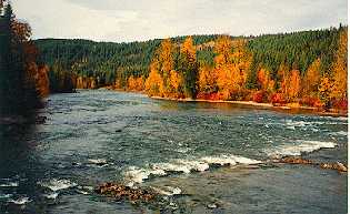
Quesnel Lake is the largest lake in the Cariboo,
with more than 500 km of scenic shoreline. One spot in the
lake is over 610 metres deep. Likely, at the west end of
the lake, was originally called Quesnel Dam. The name was
changed to honour John A. Likely of the Bullion Pit Mine,
who was affectionately called "Plato" for his
tendency to philosophise.
In 1898 the Quesnel River was dammed near Likely to enable
down river areas to be explored for gold. During the last
week of October in 1922, more than 697 ounces of gold were
recovered at the Cedar Creek Mine. In 1935 the Bullion Pit
became the site of the largest hydraulic monitors ever installed
in North America. It operated from 1892 to 1942, constructing
over 64 kilometres of canals to draw water from nearby lakes
and creeks to feed the hydraulic nozzles. In fact, Morehead
Lake was created to supply water to the Bullion mine.
Today, the Bullion Pit stands as an astonishing man-made
canyon which can be viewed from the trail above.
Just over the hill from Likely is the ghost town of Quesnel
Forks. At one time, one of British Columbia's largest communities,
now a collection of historic buildings where the Cariboo
and Quesnel rivers meet. A lovely setting for a picnic in
a spot where time stands still.
Plan a visit to Likely in late August and watch thousands
of salmon migrate up the Quesnel River to their spawning
grounds in the Horsefly and Mitchell Rivers. Be sure to
visit Cedar Point Park, an impressive stand of yellow cedar
on the shores of Quesnel Lake. Once a rendezvous point for
the Hudson's Bay fur brigade in the 1850's, Cedar Point
is now a park and campground.
Accommodation/Adventure
Providers
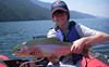
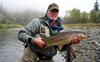
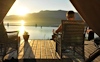
Elysia Resort: Our full service getaway destination on Quesnel Lake offers fishing for Rainbow Trout, romantic getaways, great dining, and vacation packages in lakeview rental cabins & guest rooms. You'll be warmly greeted at our small, friendly and secluded piece of paradi... more
Northern Lights Lodge: A unique fly fishing lodge offering guided fly fishing on 4 wilderness rivers in the Cariboo Mountains. Wild native Rainbow Trout on the fly! more
Plato Island Resort: We offer excellent fishing on Quesnel lake, camping & comfortable cabin accommodation, a well protected marina, & delicious quality meals. See you soon! more
If you would like to have your business listed, please Click Here.
City
Information
Access: Likely,
British Columbia, is located 85 km (53 mi) east of 150
Mile House off BC Hwy 97 on the Likely Road.
Accommodations:
Motel rooms are available in the community, as well as several
nearby lakeshore cabins and resorts on West Quesnel Lake
and Morehead Lake.
Campsites: Cedar
Point Park offers lakeshore campsites with no hookups; A
Forest Service campsite is located north of Likely on Cariboo
Lake; Camper/trailer hookups are available at nearby resorts.
For
Information:
Likely
Info Centre
Telephone: (250) 790-2422 (seasonal)

 One
of the few remaining Cariboo Gold Rush settlements, Likely,
British Columbia, is a small community situated where the
west arm of
One
of the few remaining Cariboo Gold Rush settlements, Likely,
British Columbia, is a small community situated where the
west arm of