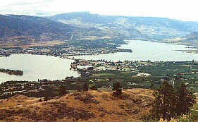
Osoyoos, British Columbia


Lodging & Services
Recreation
Cities & Towns
Lakes
Travel Info
Points of Interest
Provincial Parks
Trails


Osoyoos
Including Osoyoos, Oliver, Okanagan Falls & Kaleden


Osoyoos British Columbia

Osoyoos, BC  

Located on BC Highway 97 in the south Okanagan Valley, only five minutes from the Canada - US border, Osoyoos, British Columbia, basks in Canada's driest climate. A fact not lost on sun loving vacationers and retirees!


In fact, Osoyoos is located on Canada's only desert - the northern most tip of the Sonora Desert. Situated in the heart of the South Okanagan, and boasting the lowest annual rainfall and the highest average temperatures, this is appropriately called BC's Desert Wine Country!
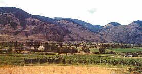
Osoyoos, BC

Once a crossroads for north-south, east west trade traffic, Osoyoos is now primarily a retirement & vacation center and orchardist area. Apricots, peaches, pears, plums, cherries, apples and grapes thrive in the hot, dry climate, while the surrounding area features desert flora and fauna such as prickly pear cactus, antelope bush and rare species of birds.
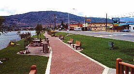
Visit Canada's warmest lake - Lake Osoyoos - for a wide array of watersports or enjoy many of the festivals and jamborees hosted here.

Fish in nearby lakes, hike the hills or golf one of the local links. Lodging, accommodation, restaurants, pubs, shops and services are located in Osoyoos.

Oyoyoos is a British Columbia First Nations word meaning "The Narrows of the Lake".


Accommodation/Adventure Providers


If you would like to have your business listed, please Click Here.

City Information

Accommodations: The entire Osoyoos area has a variety of accommodations for the visitor from camping facilities in private sites and provincial parks to numerous value motels and destination hotels plus unique lodges and bed & breakfasts.

Local Attractions: Anarchist Mountain Lookout, Mt. Baldy Ski area, Equestrian Centre & Race Track, Harness point Amphitheater, Osoyoos Historic Museum, Spotted Lake

Agriculture at Osoyoos

Population: 3550

Elevation: 277 m (910 ft)

Industry: tourism and fruit growing

For Information:
Osoyoos Travel InfoCentre,
Box 227, Osoyoos, B.C. V0H 1V0
•Tel: (250) 495-7142 • Fax: (250) 495-6161


Osoyoos to Penticton

There are a number of small to mid-size communities along Highway 97 from Osoyoos to Penticton. The entire area is renowned for its many recreational activities and fascinating sites; there are plentiful orchards full of delectable fruit all summer long plus numerous lakes and rivers for camping and fishing and relaxing as well as a number of visitor services and attractions.


Okanagan Falls

Okanagan Falls is surrounded by orchards, ranches and vineyards. The visitor can explore the many well-preserved heritage buildings, and tour fine wineries and the several fruit confection facilities.

Learn more about Okanagan Falls


Kaleden

The community of Kaleden is located on Skaha Lake and provides visitors with various resort facilities, beach access, restaurant service and gas. Fruit stands, a game farm, Christie Memorial Provincial Park and a tourist information centre are nearby.

Population: 1118

Industry: tourism and fruit production

Location: Kaleden is located on Highway 97, approximately 10 minutes south of Penticton.

Learn more about Kaleden


Oliver

Oliver is located between Osoyoos and Skaha Lakes on Highway 97 in a lush fruit growing area.

Learn more about Oliver

For Information:
Oliver & District Travel InfoCentre,
36205 93rd St. Box 460, Oliver, B.C. V0H 1T0
• Tel: (250) 498-6321 0149 • Fax (250) 498-3156

Thompson Okanagan Tourism Association
2280-D Leckie Road, Kelowna, BC, V1X 6G6
Telephone: (250) 860-5999 • Fax: (250) 860-9993
Plan a Vacation
Lodging & Services: more info
Accommodations Adventures Attractions
Events Dining & Entertainment Shopping
Transportation Conference Centers Publications & Media
Recreation: more info
Attractions ATV Boating
Camping Canoeing & Kayaking Dog Sledding
Fishing Golf Guest Ranches
Health/Spas Cat & Heli-Skiing Hiking
Houseboating Mountain Biking Mountain Climbing
Multisport Natural Hot Springs River Rafting
Skiing Snowmobiling
Regional Information
Cities & Towns Lodging, Hotels, Services & Events . . more info
Lakes Resorts, Cabins, Fishing Info, Maps . . more info

Travel Info Travel Journals, Tourist Info Centers, Weather, Road Conditions, BC Ferries Info, Travel Planner . . more info

Points of Interest . . more info
Provincial Parks . . more info
Trails Hiking & canoeing trails . . more info

Area Maps of the Okanagan Similkameen
Hwy 3 Hope-Princeton:
Princeton
Hwy 5A (North of Princeton) & Hwy 97C (East of Aspen Grove):
Allison to Pennask
South Okanagan:
Osoyoos to Penticton Kettle Valley
Hwy 3 Boundary:
Greenwood, Grand Forks, Christina Lake
Central Okanagan:
Kelowna Winfield
North Okanagan:
Vernon to Armstrong Falkland Monashees (to Kootenays)


Advertise With Us
Promote your business on the BC Adventure Network.
BC's largest and most visited tourism Web site . . . more info.

Advertising Inquiries:
advertising@ibcnetwork.com

© 1995 - 2018 Interactive Broadcasting Corporation


Follow Us On Facebook


List of BC Adventure
Advertisers

Site Info
Advertise With Us
Awards
About Us
Contact Us


Free Vacation Guides
BC Vacation Guides
Coastal Vacations
Thompson Okanagan
EcoTourism
Fishing Vacations
Guest Ranch Guide
Romantic Getaways
Wilderness Vacations
Winter Vacations
The Rockies Guide


Login


Osoyoos, British Columbia